cancel
Showing results for 
Show  only  | Search instead for 
Did you mean: 
  • Don’t miss your chance to experience Discovery Summit Europe at our best available rate! Early bird registration through 31 Oct.
  • Image to Table JMP extension imports single or batch images as data tables. Useful to extract curves from pictures or convert image data to curve data to use in analyses like Functional Data Explorer. Download and install the extension.

Discussions

Solve problems, and share tips and tricks with other JMP users.
Choose Language Hide Translation Bar
Machine23
Level I

How do I get Street Map Service to align up with my data

I have some latitude and longitude data that I place in graph builder.  When I select Simple Earth and Detailed Earth as a background map the data aligns perfectly.  When I select Street Map Service the data is not aligned with map.  Not sure what I can do to get this fixed.  Sometimes it seems to work, and sometimes it does not.
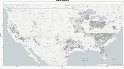
 

Machine23_0-1677605827193.png


1 REPLY 1
Phil_Kay
Staff

Re: How do I get Street Map Service to align up with my data

I see the same issue when I try to use Street Map. NASA Server appears to be okay. I suggest that you ask technical support to look into this: [email protected].

Recommended Articles