JMP Blog
A blog for anyone curious about data visualization, design of experiments, statistics, predictive modeling, and more- JMP User Community
- :
- Blogs
- :
- JMP Blog
- :
- Jump into the car for the road trip of a lifetime! (Part 3)
- Subscribe to RSS Feed
- Mark as New
- Mark as Read
- Bookmark
- Subscribe
- Printer Friendly Page
- Report Inappropriate Content
In my previous posts, I discussed how I derived an algorithm to help me find a road trip across all primary US Highways and then showed some results of (hopefully) improving quality. The first hurdle I had to jump was making sure my path went through every state. That was easy enough to fix once I got a better understanding of my network.
The next hurdle was to try to find a path that was not so “messy.” For this part, my attempts primarily involved adding more constraints into the algorithm. Specifically, as I played around with various paths returned by my algorithm, I would find parts that I thought more pleasing than others and so would internally force the algorithm to include these paths in future runs. I may have gotten a bit carried away with this (for my final path, I ended up specifying the first 31 nodes in the path before running the algorithm so…yeah). But at long last, after more back and forth between the algorithm’s output and my own machinations, I ended up with my final path as shown in Figure 1 (cue angelic choir, Viking war chant, or other epic sounds of your choice).
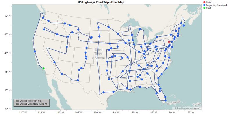
As you can see, there appears to be less clutter in the path, particularly in the Western section. This final path was the result of several attempts and playing around with different options for where the path would go and what cities it would visit until I finally ended up with one that I was satisfied with. The manner in which I implemented this with the algorithm involved some very high-level coding and graph theory, the details of which I couldn't possibly bore you with. What's that? You want the details?...You sure? They're quite complex....OK, OK, you got me. To be honest, I simply input the nodes either directly into the starting path or as a fixed point within my algorithm. For example, my starting path consists of 31 nodes...yeah. But hey, the algorithm still had to do some work to make the connections between my fixed points, so I consider this an example of user and machine working in beautiful harmony.
You may have noticed the gray box in the lower left corner with some simple summary stats. Because what kind of statistician would I be without computing some stats, right? If you didn't see it, I'll give you a few seconds to find it...OK, good. Yes, you're reading those numbers right. This road trip certainly lives up to its "ultimate" designation. To put things in perspective, this trip would take roughly three to six months to complete (based on a range of four to eight hours of driving per day, depending on preference) and would be the equivalent of driving around the Earth nearly one and a half times. Talk about committment! As I alluded to in a comment on the previous post, I compute these times and distances through painstaking research on Google Maps. I imagine there is a faster way to do it in the future, so I'm open to suggestions!
Now what say we dive in and explore some of the features of this path, eh?
Break it Down, Road Trip Style!
Let’s walk step-by-step and hand-in-hand through this road trip, shall we?...OK, we can skip the hand-in-hand thing. To help us out, I’ve removed the Street Maps background temporarily to reduce clutter and added in the major city labels. I apologize beforehand if I missed any city you might consider “major.” I confess I was a bit wishy-washy with my definition. You could say it was more or less based on a Google Maps “zoom-out standard,” by which I mean that these cities remained visible in Google Maps when you zoomed out to a certain point (I can feel NIST glaring at me).
Also, while we’re at confessional, I must also confess that I had to break a rule I set in the first post; specifically, it's the one in which I want to go directly from one highway to another without traveling a non-highway in between. There are only a few places I did this, but my justification was to ensure a particular city or scenic route was part of the path, so I hope you can forgive me on that account.
Alrighty then, let’s dive in! The first part of the trip is a whirlwind tour of the West (see Fig. 2). One thing I like about this trip overall is how well it reflects the density of highways across the US. The highway system becomes more sparse as you move West, which is a reflection of the manner in which the country was settled.

A few of my other adjustments include:
- Having US 14 cross to US 16 closer to Rapid City so that you would pass close enough to Mt. Rushmore to stop by for a visit.
- I noticed in previous paths that some of the most famous and major cities in my former home state of New Mexico were left out! That simply would not do. So I made sure such gems as Santa Fe, Albuquerque and Las Cruces made it onto the path.
- That horizontal strip through Nevada is part of US 50, a cross-continental highway. That particular portion is famously advertised as the “Loneliest Road in America” since it crosses the deserts of Nevada. While some might be a bit timid about trying such a trek, it did allow for a connection to US 87 that brought you up through Salt Lake City, where you can stop for refreshment (preferably not from the nearby Salt Lake).
The next part involves a long ride on US 20, the longest highway in the US (Fig. 3). Besides epitomizing the thrill of a road trip, this highway also passes through or close to such famous scenery as Yellowstone National Park and Niagara Falls. It also serves as a nice transtion from West to East, in my opinion.

After the long haul of US 20, the path stair-steps through New England toward the Canadian border in Maine (Fig. 4). On the way, you pass through the national forests of Green Mountain and White Mountain (if you’re wondering where Red Mountain national forest is, try Arizona.…Oh wait, that’s Red Rocks...sorry, word play can be quite addicting). I found this to be a nice route through Vermont, New Hampshire and Maine, providing good coverage for each of them.
Once you’ve enjoyed some fresh New England air, it’s time for another long trip, this time down US 1 (Fig. 5). The official name for this road is the Atlantic Highway, but I think a better title would bethe East Coast Road of Fame. All the big cities are here: Boston, New York, Philadelphia, DC, Raleigh, Jacksonville, Miami. Suffice it to say, this road is a tourist’s dream come true. Plus, you get to avoid much of the traffic on nearby I-95! At least, outside of DC….


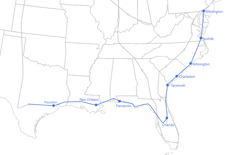
Next, we transition from seas of grain to seas of…well, seas. Specifically, this next part of the path follows along the Gulf Coast, then transitions across the interior of Florida (through a particularly magical city) to the Atlantic Coast (Fig. 9).
This part of the path, particularly the Gulf Coast, tended to be lacking in the previous path options, so I forced it in using a fixed point in the algorithm. One of the highlights is that, from Norfolk, you actually get to cross over and under water on the Chesapeake Bay Bridge-Tunnel (for a nominal fee).
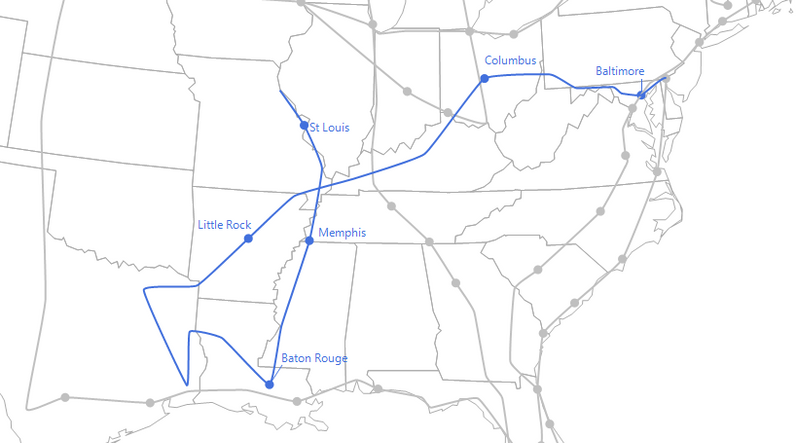
From the sea, the path moves inland and transitions to smaller bodies of water (Fig. 10). It follows along the Ohio River in Kentucky and meanders about in the Texarkana region before moving up the Mississippi River. There is one last fake connection in Baton Rouge as I couldn’t miss the opportunity to include it in my path. Fun fact: Part of US 61, which is the highway that follows the Mississippi, coincides with the Great River Road, which is a National Scenic Byway that follows the river from its start in Minnesota all the way down through nine other states to its end at the Gulf of Mexico in Louisiana.


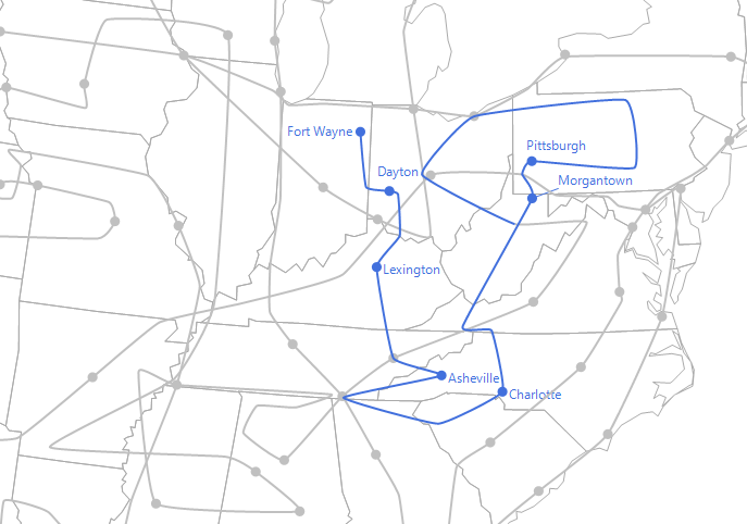
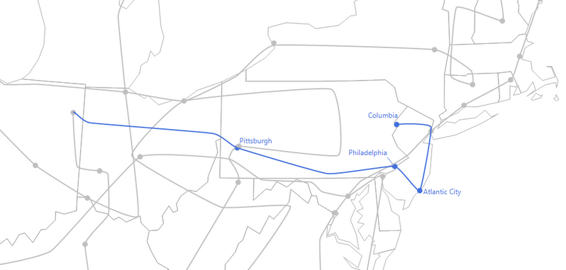
From there, the path makes a beeline through Amish country in Pennsylvania to the Jersey shoreline. This allows for some scenic views of the coast before finally reaching the journey's end in Columbia, NJ (Fig. 14).
Now It's Your Turn!
Well, if you're still reading this post after that long guided tour, I'd like to thank you for sticking with me to the end. This process was about as involved as I'm sure undertaking the actual road trip would be. I have a feeling through all of this that you've been coming up with your own ideas of how you would generate your own trip or perhaps how you could've made the process more efficient. Maybe you've even thought about ways to make the trip more "optimal," such as perhaps minimizing the driving time or distance or maximizing some type of "scenic score," in which case you would be firmly in the territory of the famous Traveling Salesman Problem.
.If that's your cup of tea, then perhaps you can try your hand at generating a JSL algorithm of your own. Or if you are savvy with SAS, you can use the PROCOPT or other related procedures. I've seen some examples of this in SAS, and it's pretty awesome! To help you along, I've posted the JSL code I used as well as my database of highway intersections. I'm excited to see what my fellow JMP (and SAS) users can produce. And who knows? Maybe I just might meet you on my ultimate road trip!
- © 2026 JMP Statistical Discovery LLC. All Rights Reserved.
- Terms of Use
- Privacy Statement
- Contact Us

You must be a registered user to add a comment. If you've already registered, sign in. Otherwise, register and sign in.